Display photos:
Before/after comparison photo of Monte Rosa glacier (Valais Alps)
Height: ca. 2950 - 4520m.a.s
Location: Zermatt, Matter valley, Valais, Switzerland
Show glacier on:
Swiss map...
The Monte Rosa glacier (Monte Rosagletscher) covers the northwestern flank of the Monte Rosa massif, where the 4634m high Dufourspitze, the highest peak in Switzerland, is located. The normal routes from the Monte Rosa hut to the Dufourspitze and the neighboring Nordend peak (4608m) lead over the Monte Rosa glacier.
The Monte Rosa glacier flowed into the Gorner glacie r(Gornergletscher) until about 1960.
C Location 1
Inserted: 13.11.2021
Height: 2769m Viewing direction center of photo: ESE (122°)
Compare the situation from with that from (<<< select date) Period of time: 4035 days (= 11.05 years)
The
terms of use for these repeat photos can be found
here...
Direct link...
Summits: Nordend (4608m, approx. center of picture), Dufourspitze (4634m), Parrotspitze (4434m, right back).
Distance photo location - glacier terminus: approx. 5km.
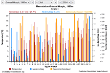
M Current meteo and climatic data for the Monte Rosa glacier.
The meteorological/climate data from the MeteoSwiss measuring stations closest to the Monte Rosa glacier have been available since December 2023. You can call up the daily and monthly values for temperature (incl. min/max values), precipitation and sunshine duration, a comparison with the climate standard values and exceptional weather events. Links to the nearest snow depth measuring stations on the Monte Rosa glacier round off the offer.

The image comparisons of this page were created with the software
Before/After images.
|<<>>|Overview C M I