Display photos:
Before/after comparison of Festi glacier (Valais alps)
Height: ca. 3020 - 4275m.a.s.
Location: Randa, Mattertal, Valais, Switzerland
Show glacier on:
Swiss map...
The Festi glacier (Festigletscher) is located on the west side of the Dom, which at 4545m is the highest peak of the Mischabel massif. The normal route from the Domhut to the Dom leads a bit over the part of the Festigletscher visible on the photo.
C Location 1 Inserted: 07.01.2020
Height: 2226m
Image comparison period: 20.07.2015 - 22.07.2019 Period of time: 1463 days (= 4.01 years)
The
terms of use for these repeat photos can be found
here...
Direct link...
The horizontal distance from the location 1 to the glacier tongue is about 6.7km.
The dark summit on the right of the picture is the Grabenhorn (3370m). On the comparison photo you can see that the sunlit flank (called Grabengufer) has moved downhill in the last 4 years. This flank has been causing problems for quite some time and is the reason why the Europaweg today traverses this valley further down via the Charles Kuonen suspension bridge. This suspension bridge is almost 500m long.
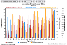
M Current meteo and climatic data for the Festi glacier.
The meteorological/climate data from the MeteoSwiss measuring stations closest to the Festi glacier have been available since December 2023. You can call up the daily and monthly values for temperature (incl. min/max values), precipitation and sunshine duration, a comparison with the climate standard values and exceptional weather events. Links to the nearest snow depth measuring stations on the Festi glacier round off the offer.

Show from Festi glacier:Photos
The image comparisons of this page were created with the software
Before/After images.
|<<>>|Overview C M I