C Location 4
Inserted / Updated : 04.03.2018 / 01.10.2019
Height: 2700m Viewing angle: 27° Viewing direction center of photo: E (78°)
Compare the situation from with that from (<<< select date) Period of time: 3280 days (= 8.99 years)
The
terms of use for these repeat photos can be found
here...
Direct link...
The decline in the Findel Glacier is noticeable in the area of the tongue. Summit: Rimpfischhorn (4199m) on the left and Strahlhorn (4190m) on the right. In between is the Adler Glacier.
In addition to the melting of the glacier, it is also easy to see how the eastern (= in the direction of view left) lateral moraine has changed in the area of the landslide. This is how the landscape was and is formed.
Horizontal distance to the damaged area in the lateral moraine: approx. 5km (measurement map.admin.ch).
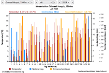
M Current meteo and climatic data for the Findel glacier.
The meteorological/climate data from the MeteoSwiss measuring stations closest to the Findel glacier have been available since December 2023. You can call up the daily and monthly values for temperature (incl. min/max values), precipitation and sunshine duration, a comparison with the climate standard values and exceptional weather events. Links to the nearest snow depth measuring stations on the Findel glacier round off the offer.

The image comparisons of this page were created with the software
Before/After images.