The Grueben Glacier (Gruebengletscher) lies in a valley basin WSW above Handegg on the Grimsel Pass in the eastern Bernese Alps. North of the glacier on a spur lies the Grueben hut which is without staff and serves as a starting point for various tours in the region.
On the latest national maps, the Grueben glacier is now called the Gröeben glacier. On this website we use the name that has been in use since 1973. From our point of view it is neither sensible nor efficient to change proven geographical names.
C Location 1
Inserted / Updated : 15.05.2019 / 17.08.2019
Height: 2345m Viewing direction center of photo: WSW
Compare the situation from with that from (<<< select date) Period of time: 3603 days (= 9.87 years)
The
terms of use for these repeat photos can be found
here...
Direct link...
The photos from 2018 were taken earlier in the year than those from 2009 and 2019. Accordingly, there was even more snow.
The photo from 2019 shows that the tongue has lost contact with the glacier. Not just yesterday, but a few years ago. There is now a large amount of ice without new ice (= dead ice) in the plain WSW of the lake. This dead ice is expected to melt in the coming years.
P Interactive panoramic photos of the Grueben glacierAfter clicking on a preview photo, the panorama photo is displayed in a new window.
09.08.2019
O Our observations at the Grueben glacierDate: 9.8.2019
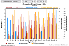
M Current meteo and climatic data for the Grueben glacier.
The meteorological/climate data from the MeteoSwiss measuring stations closest to the Grueben glacier have been available since December 2023. You can call up the daily and monthly values for temperature (incl. min/max values), precipitation and sunshine duration, a comparison with the climate standard values and exceptional weather events. Links to the nearest snow depth measuring stations on the Grueben glacier round off the offer.

The image comparisons of this page were created with the software
Before/After images.